Record updated successfully
<p>
Met zijn 4cm voor 1 km (2 ½ cm voor 1 mijl) schaal, is de OS Explorer kaartenserie de ideale en meest gedetailleerde kaartenreeks voor mensen die graag outdoor-activiteiten zoals fietsen, wandelen, paardrijden, klimmen en watersporten.</p>
<div>
Deze kaart is nog gedetailleerder dan de 'gewone' Landranger maps. Voor- en achterzijde bedrukt! Zeker op de moors en andere natuurgebieden van onschatbare waarden met echt alle aspecten van het landschap op de kaart ingetekend. Zeer goede detailkaart met topografische ondergrond. Hierop zijn toeristische symbolen van bezienswaardigheden ingetekend, daarnaast staan bijvoorbeeld campings en jeugdherbergen vermeld en - voor wandelaars het belangrijkst - alle right of way paden en Lange afstands Wandelpaden zijn er op te vinden. De ideale kaart voor het wandelen in Engeland, Wales of Schotland.</div>
<div>
</div>
<div>
<div>
Experience ‘Scotland in miniature’ on the Isle of Arran, with its rocky, wild highlands in the north and lush lowlands in the south. Climb Goat Fell, the highest point on the Isle of Arran, for spectacular panoramic views or explore the mysterious standing stones on Machrie Moor.</div>
<div>
</div>
<div>
Take the Arran Coastal Way to discover the King’s Cave in the sandstone cliffs and the beaches of Blackwaterfoot</div>
<div>
Visit Brodick Castle, with its subline views across to the Ayrshire coast, or take a boat to Holy Isle with its ancient spiritual heritage and unspoiled beauty</div>
<div>
Walk, hike or cycle along the Arran Coastal Path, climb jagged summits and rocky ridges and glimpse red squirrels, red deer, golden eagles and otters</div>
<div>
</div>
<div>
</div>
<div>
OS Explorer Active Maps:</div>
<div>
</div>
<div>
1:25 000 scale (4 cm to 1 km – 2½ inches to 1 mile).</div>
<div>
Laminated with a weatherproof finish, also suitable for dry-wipe pens. </div>
<div>
Great for walkers, hikers, cyclists, families, dog walkers, and horse riders.</div>
<div>
Includes roads, rights of way, permissive paths and bridleways, plus essential visitor information.</div>
<div>
Free digital download included.</div>
<div>
Other Ordnance Survey Explorer maps of Kintyre include Kintyre South map 356 and Kintyre North map 357</div>
</div>
<p>
</p>
€ 25.96
Bekijk bij dezwerver.nl| Tags | WandelkaartTopografischeKaartExplorerMapActiveIsleArranOrdnanceSurvey |
| Identifier | 11695 |
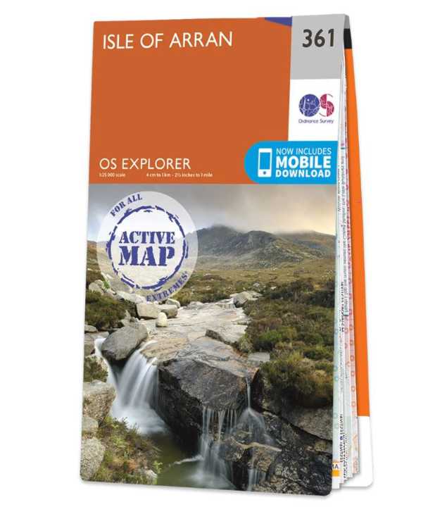
| Name | Wandelkaart - Topografische kaart 361 OS Explorer Map | Active Isle of Arran | Ordnance Survey |
| ProductCategoryName | Topografische kaarten |
| Description | <p> Met zijn 4cm voor 1 km (2 ½ cm voor 1 mijl) schaal, is de OS Explorer kaartenserie de ideale en meest gedetailleerde kaartenreeks voor mensen die graag outdoor-activiteiten zoals fietsen, wandelen, paardrijden, klimmen en watersporten.</p> <div> Deze kaart is nog gedetailleerder dan de 'gewone' Landranger maps. Voor- en achterzijde bedrukt! Zeker op de moors en andere natuurgebieden van onschatbare waarden met echt alle aspecten van het landschap op de kaart ingetekend. Zeer goede detailkaart met topografische ondergrond. Hierop zijn toeristische symbolen van bezienswaardigheden ingetekend, daarnaast staan bijvoorbeeld campings en jeugdherbergen vermeld en - voor wandelaars het belangrijkst - alle right of way paden en Lange afstands Wandelpaden zijn er op te vinden. De ideale kaart voor het wandelen in Engeland, Wales of Schotland.</div> <div> </div> <div> <div> Experience ‘Scotland in miniature’ on the Isle of Arran, with its rocky, wild highlands in the north and lush lowlands in the south. Climb Goat Fell, the highest point on the Isle of Arran, for spectacular panoramic views or explore the mysterious standing stones on Machrie Moor.</div> <div> </div> <div> Take the Arran Coastal Way to discover the King’s Cave in the sandstone cliffs and the beaches of Blackwaterfoot</div> <div> Visit Brodick Castle, with its subline views across to the Ayrshire coast, or take a boat to Holy Isle with its ancient spiritual heritage and unspoiled beauty</div> <div> Walk, hike or cycle along the Arran Coastal Path, climb jagged summits and rocky ridges and glimpse red squirrels, red deer, golden eagles and otters</div> <div> </div> <div> </div> <div> OS Explorer Active Maps:</div> <div> </div> <div> 1:25 000 scale (4 cm to 1 km – 2½ inches to 1 mile).</div> <div> Laminated with a weatherproof finish, also suitable for dry-wipe pens. </div> <div> Great for walkers, hikers, cyclists, families, dog walkers, and horse riders.</div> <div> Includes roads, rights of way, permissive paths and bridleways, plus essential visitor information.</div> <div> Free digital download included.</div> <div> Other Ordnance Survey Explorer maps of Kintyre include Kintyre South map 356 and Kintyre North map 357</div> </div> <p> </p> |
| Price | 25.96 |
| Extra informatie | |
|---|---|
| Pages | None |
| Edition | 2021 |
| ISBN | 9780319475775 |
| Subcategories | Wandelkaart / Topografische kaart |
| Publisher | Ordnance Survey |
| Continent | Europa |
| Country | Schotland |
| Region | Lowlands | Schotse Laaglanden en grenzen |
| DeliveryCosts | 2.95 |
| Language | Engels |